Notice
Following a review of the Buildings at Risk Register we have paused the Register while we consider options for its future.
The website will remain accessible and searchable during this time, but it will not be updated and we’re not accepting nominations for additions to the Register. If you need to contact us about the BARR please email hmenquiries@hes.scot
Read the review report here and you can find out more about why we have paused the BARR on our news centre.
Port Bannatyne Steamer Pier, Port Bannatyne
Ordnance Survey licence number AC0000807262. All rights reserved. © Copyright and database right 2025. Public Sector Viewing Terms
Useful Links
General Details and Location
Category
AT RISK
Name of Building
Port Bannatyne Steamer Pier
Other Name(s)
Address
Port Bannatyne
Locality
Postcode
Planning Authority
Divisional Area
Reference No
4683
Listing Category
Unlisted
OS Grid Ref
NS 07589 67401
Location Type
Small Town
HS Reference No
Description
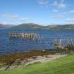
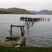
A t-plan former pier of timber construction, now with only the timber supports and landward structures in stone remaining.
Port Bannatyne, previously Kamesburgh until its acquisition by the Marquess of Bute in the 1860s, experienced boom years during the turn of last century as a tourist destination when Caledonian steamers called regularly at the pier, with trams bringing the holiday makers round from Rothesay (FA Walker with F Sinclair).
Port Bannatyne, previously Kamesburgh until its acquisition by the Marquess of Bute in the 1860s, experienced boom years during the turn of last century as a tourist destination when Caledonian steamers called regularly at the pier, with trams bringing the holiday makers round from Rothesay (FA Walker with F Sinclair).
Building Dates
1857
Architects
Unknown
Category of Risk and Development History
Condition
Ruinous
Category of Risk
High
Exemptions to State of Risk
Field Visits
03/12/2009, 30/8/12
Development History
December 2009: Inspection finds the pier a ruin, slowly decaying. The pier is understood to have been derelict from around 1937.
30 August 2012: External inspection finds no significant change from the previous site visit.
Availability
Current Availability
Unknown
Appointed Agents
Price
Occupancy
Vacant
Occupancy Type
N/A
Present/Former Uses
Name of Owners
Unverified see FAQ on ascertaining ownership
Type of Ownership
Unknown
Information Services
Additional Contacts/Information Source
Bibliography
North Clyde Estuary an illustrated architectural guide (1992) Frank Arneil Walker with Fiona Sinclair p162-3.
Online Resources
Classification
Shipping
Original Entry Date
08-JUN-10
Date of Last Edit
25/08/2017


