
Buildings at Risk Register Paused
Following the review of the Buildings at Risk Register the decision has been taken to pause the BARR in order to consider long-term options for its future.
The existing BARR website will remain accessible as a resource, however it will not be updated and we're not accepting nominations for additions to the Register.
Downtime
Please be advised that this website will undergo scheduled maintenance on the following dates:
Sunday 23rd November 18:00 to Monday 24 November 09:00
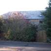
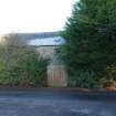
Benvie Mill (Former), Benvie


Ordnance Survey licence number AC0000807262. All rights reserved. © Copyright and database right 2026. Public Sector Viewing Terms
Useful Links
- NRHE:
- BENVIE MILL AND MILLER'S HOUSE
- Historic Scotland:
- HS Reference No 10864
General Details and Location
Category
AT RISK
Name of Building
Benvie Mill (Former)
Other Name(s)
Address
Benvie
Locality
Postcode
Planning Authority
Divisional Area
Reference No
3770
Listing Category
A
OS Grid Ref
NO 32809 31493
Location Type
Rural
HS Reference No
10864
Description
2-storey and basement, rectangular-plan grain mill. rubble masonry, droved and margined dressings, piended slate roof. West elevation features; segmental-arched cart entrance to centre right, window to right, low entrance to wheel chamber to left, 2 windows above to ground floor, door to far left, window to outer left, low stone steps advanced at left angle; 4 small boarded windows to 1st floor; remains of cowl at roof ridge over kiln to right. INTERIOR: mill; wheel and all machinery intact.
Neither mill nor house is shown on the 1810 map; both appear on the first Ordnance Survey map. The date 1865 inscribed on the basement door lintel to the east gable of the house probably refers to the addition of the 1st floor. Benvie Mill forms a B group with the Road Bridge over Fowlis Burn near Benvie Mill, Benvie Church Ruin and Churchyard, and Benvie Farmhouse. The mill is A listed for the survival of its machinery. (Historic Environment Scotland List Entry)
Neither mill nor house is shown on the 1810 map; both appear on the first Ordnance Survey map. The date 1865 inscribed on the basement door lintel to the east gable of the house probably refers to the addition of the 1st floor. Benvie Mill forms a B group with the Road Bridge over Fowlis Burn near Benvie Mill, Benvie Church Ruin and Churchyard, and Benvie Farmhouse. The mill is A listed for the survival of its machinery. (Historic Environment Scotland List Entry)
Building Dates
Earlier 19th century
Architects
Unknown
Category of Risk and Development History
Condition
Fair
Category of Risk
Moderate
Exemptions to State of Risk
The adjoining house to south-east is not at risk and therefore excluded from this record.
Field Visits
26/01/2009, 16/02/2010, 27/5/2016
Development History
January 2009: External inspection suggests that the mill is disused. The exterior of the building appears to be in reasonable condition. However, the glass is missing from a window on the upper floor of the west elevation.
February 2010: External inspection finds the mill appears largely unchanged from the previous visit, remaining in fair condition. Ground floor windows are boarded up while first floor windows are open to the elements.
27 November 2012: Local planners advise the owner aims to convert the former mill to residential use.
18 June 2014: Listed Building Consent to repair the building and convert to residential use with retention of existing mill machinery is currently being sought ref: 14/00359/LBC.
27 May 2015: Limited external inspection possible. Overall the building remains in much the same condition as seen previously. Rainwater goods are beginning to leak and stain walls and a dip is developing on the western roof pitch. Consents for repairs and conversion to residential use (previously noted) were conditionally approved July 2014.
7 December 2016: Listed Building Consent for external repairs/ alterations is being sought ref: 16/00914/LBC.
5 April 2024: Previously noted listed building consent (16/00914/LBC) conditionally granted 16/01/2017. Completion certificate (17/00735/DOM3) have been issued for some works, suggesting roofing repairs have been completed.
Guides to Development
Conservation Area
Planning Authority Contact
PAC Telephone Number
01382 433105
Availability
Current Availability
Not Available
Appointed Agents
Price
Occupancy
Vacant
Occupancy Type
N/A
Present/Former Uses
Name of Owners
Unverified see FAQ on ascertaining ownership
Type of Ownership
Unknown
Information Services
Additional Contacts/Information Source
Bibliography
N McLean, surveyor, Plan of Barony of Gray and Benvie, 1810, RHP 32999/6-7; OS map, 1859. McKean & Walker (1984), p.171.
Online Resources
Classification
Food and Drink Processing
Original Entry Date
27-JAN-09
Date of Last Edit
30/05/2016