
Buildings at Risk Register Paused
Following the review of the Buildings at Risk Register the decision has been taken to pause the BARR in order to consider long-term options for its future.
The existing BARR website will remain accessible as a resource, however it will not be updated and we're not accepting nominations for additions to the Register.
Downtime
Due to maintenance taking place on Sunday 6.00pm on 1st of March to Monday 2nd March at 9.00am, services might be disrupted or temporarily unavailable. We apologise for any inconvenience.
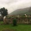
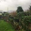
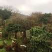
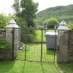
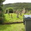
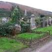
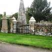
Old Burial Ground, Kilkerran Cemetery, Campbeltown


Ordnance Survey licence number AC0000807262. All rights reserved. © Copyright and database right 2026. Public Sector Viewing Terms
Useful Links
- NRHE:
- KILKERRAN CHURCHYARD AND CEMETARY
- Historic Scotland:
- HS Reference No 22962
General Details and Location
Category
AT RISK
Name of Building
Old Burial Ground
Other Name(s)
Address
Kilkerran Cemetery, Campbeltown
Locality
Postcode
Planning Authority
Divisional Area
Reference No
4268
Listing Category
B
OS Grid Ref
NR 72792 19354
Location Type
Urban
HS Reference No
22962
Description
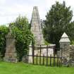
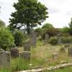
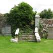
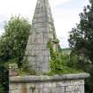
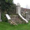
Part of a substantial cemetery comprising a series of areas enclosed by random rubble walls, with old churchyard to NE, bounded by later cemetery to S and E, with early 20th century addition on hillside to SW. Old graveyard: c entral path flanked by enclosures, random rubble walls with ashlar copes and variety of decorative cast-iron railings, some with inscriptions on marble plaques. Enclosure to Lamb family with dwarf wall and iron grated roof. Further enclosures stretching along crest of hill to E, including; Random rubble coped enclosure to MacEacharn monument, high wall to rear with sandstone panel dated 1715 at centre flanked by fluted pilasters and with winged cherubs head superimposed on frieze. Stewart family enclosure, dated 1878, deep ashlar cope to dwarf wall surmounted by Gothick cast-iron railing, memorial at rear comprising 3 round-arched marble panels with inscriptions, frieze and cornice above surmounted by curvilinear pediment with floreate carving to pediment and flanking urns (left urn missing). Enclosure to MacFarlane family immediately comprising random rubble dwarf wall with ashlar cope and wrought-iron railing. Classical pedimented memorial at rear with architraved marble panels. To W, 19th century Celtic cross to Campbell of Kildalloig with foliate and animal carvings, and ashlar coped enclosure. To N, Strichen's Tomb (also known as the Mystery Tomb) ashlar block construction, corniced square base, barrel-vaulted interior accessed by round-arched opening with keystone, elongated pyramid over base with bolection-moulded frames to blank panels on each face.
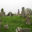
Variety of gravestones, recumbent slabs and enclosures mainly from 17th century onwards around site of former kirk (remains no longer visible) including small headstones depicting figures, tools, animals, and classical motifs. Random rubble enclosure (without railings) comprising dwarf wall with ashlar cope, table slab at centre commemorating Rev James Boes. Polished grey granite memorial slab dated 1904 to James Macalister Hall of Tangy and Killean, mounted on corniced pedestal of stugged grey granite with sandstone ashlar dressings, cast-iron railings to enclosure. The church dedicated to St Ciaran is first recorded shortly before the middle of the 13th century, the medieval parish apparently embracing the eastern portion of the peninsula lying between Campbeltown Loch and Balnabraid Glen, together with Davaar Island. After the reformation, the parishes of Kilmichael, Kilchousland and Kilkivan were joined in 1617 to Kilkerran, the united parish afterwards being named Kinloch (or Lochhead), and subsequently Campbeltown. Ruins of the medieval church were still visible in the 1870's. The quality and historical interest of the stones in Kilkerran Cemetery reflects the important ancient history and more recent prosperity of this part of Argyll.( Historic Scotland)
Variety of gravestones, recumbent slabs and enclosures mainly from 17th century onwards around site of former kirk (remains no longer visible) including small headstones depicting figures, tools, animals, and classical motifs. Random rubble enclosure (without railings) comprising dwarf wall with ashlar cope, table slab at centre commemorating Rev James Boes. Polished grey granite memorial slab dated 1904 to James Macalister Hall of Tangy and Killean, mounted on corniced pedestal of stugged grey granite with sandstone ashlar dressings, cast-iron railings to enclosure. The church dedicated to St Ciaran is first recorded shortly before the middle of the 13th century, the medieval parish apparently embracing the eastern portion of the peninsula lying between Campbeltown Loch and Balnabraid Glen, together with Davaar Island. After the reformation, the parishes of Kilmichael, Kilchousland and Kilkivan were joined in 1617 to Kilkerran, the united parish afterwards being named Kinloch (or Lochhead), and subsequently Campbeltown. Ruins of the medieval church were still visible in the 1870's. The quality and historical interest of the stones in Kilkerran Cemetery reflects the important ancient history and more recent prosperity of this part of Argyll.( Historic Scotland)
Building Dates
Unknown
Architects
Unknown
Category of Risk and Development History
Condition
Poor
Category of Risk
Low
Exemptions to State of Risk
The risk record soley to the older section of the graveyard and also excludes the 3 carved stones which are Scheduled Monuments.
Field Visits
29/10/2009, 25/7/2012, 05/12/2018
Development History
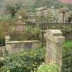
October 2009: Site inspection finds the older section of the cemetery overgrown and the surrounding walls damaged in places are requiring repointing. Gates are broken in places, monuments are overgrown and some are broken. Public access to the area has been restricted. The rest of the cemetery site is well maintained.
25 July 2012: Inspection finds no significant change from the previous site visit.
5 December 2018: Inspection finds the old burial ground remains in poor condition. Fallen masonry and damage to the boundary walls and iron railings is evident. There is extensive vegetation growths on the stonework and gravestones. Deterioration continues.
Availability
Current Availability
Unknown
Appointed Agents
Price
Occupancy
Unknown
Occupancy Type
N/A
Present/Former Uses
Name of Owners
Type of Ownership
Unknown
Information Services
Additional Contacts/Information Source
Bibliography
Online Resources
Classification
Cemeteries and Graveyards
Original Entry Date
11-NOV-09
Date of Last Edit
20/11/2012