
Buildings at Risk Register Paused
Following the review of the Buildings at Risk Register the decision has been taken to pause the BARR in order to consider long-term options for its future.
The existing BARR website will remain accessible as a resource, however it will not be updated and we're not accepting nominations for additions to the Register.
Railway Pier, North Queensferry


Ordnance Survey licence number AC0000807262. All rights reserved. © Copyright and database right 2026. Public Sector Viewing Terms
Useful Links
- NRHE:
- NORTH QUEENSFERRY HARBOUR, RAILWAY PIER
- Historic Scotland:
- HS Reference No 43863
General Details and Location
Category
AT RISK
Name of Building
Railway Pier
Other Name(s)
Address
North Queensferry
Locality
Postcode
Planning Authority
Divisional Area
Reference No
4889
Listing Category
B
OS Grid Ref
NT 12840 80249
Location Type
Small Town
HS Reference No
43863
Description
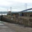
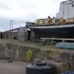
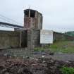
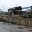
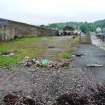
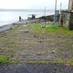
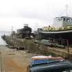
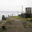
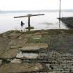
Long jetty and pier-head, with associated former goods yard pier to E. Large squared concrete blocks in courses, hammer-dressed sandstone coping; sett and concrete surfacing; steel buttresses along lower slipway; steel mooring bollards to lower and upper jetties; sloping masonry to W with ferry moorings. Entire structure partially covered by concrete render and tarmac. Square raised signal cabin, partly derelict, standing on upper level. GOODS YARD PIER: sloping coursed masonry and random rubble, tarmac surface. Associated timber and steel square disembarkation pier off shore to E, gangway now missing.
This pier served an important role in the history of the Queensferry Passage, with particular relevance to the improvement of the train service to Dunfermline prior to the opening of the Forth Bridge, which itself had been planned from 1873. The North British Railway Company secured rights to the Queensferry Passage in 1867 as an alternative to the Granton-Burntisland crossing, extending a line from Ratho first to Dalmeny then to Port Edgar (South Queensferry) by 1868. In 1872, a railway from Dunfermline to Inverkeithing and North Queensferry was planned by the Dunfermline and Queensferry Railway Company. This line was opened in 1877 and transferred to the North British Railway Company in the same year. Sir Thomas Bouch, engineer to the North British Railway, presumably designed and constructed the Railway Pier. Bouch was responsible for designing the failed Tay Bridge and also designed the first ferry in the world to transport train carriages. Dubbed the 'floating railway', this service opened in 1850, transporting goods and not passengers between Granton and Burntisland. In 1887, there were five trains per day running from Edinburgh to Dunfermline, with a ferry crossing taking ten minutes. With the opening of the Forth Bridge in 1890, the Railway Pier continued to be used as a goods pier (until 1954) and became the main landing place for road traffic until the opening of the Forth Road Bridge in 1964 when the ferry passage ceased altogether. The ferry service was taken over in 1935 by William Denny and Brothers, Dumbarton, who were probably responsible for the extension of the E slip. (Historic Scotland)
This pier served an important role in the history of the Queensferry Passage, with particular relevance to the improvement of the train service to Dunfermline prior to the opening of the Forth Bridge, which itself had been planned from 1873. The North British Railway Company secured rights to the Queensferry Passage in 1867 as an alternative to the Granton-Burntisland crossing, extending a line from Ratho first to Dalmeny then to Port Edgar (South Queensferry) by 1868. In 1872, a railway from Dunfermline to Inverkeithing and North Queensferry was planned by the Dunfermline and Queensferry Railway Company. This line was opened in 1877 and transferred to the North British Railway Company in the same year. Sir Thomas Bouch, engineer to the North British Railway, presumably designed and constructed the Railway Pier. Bouch was responsible for designing the failed Tay Bridge and also designed the first ferry in the world to transport train carriages. Dubbed the 'floating railway', this service opened in 1850, transporting goods and not passengers between Granton and Burntisland. In 1887, there were five trains per day running from Edinburgh to Dunfermline, with a ferry crossing taking ten minutes. With the opening of the Forth Bridge in 1890, the Railway Pier continued to be used as a goods pier (until 1954) and became the main landing place for road traffic until the opening of the Forth Road Bridge in 1964 when the ferry passage ceased altogether. The ferry service was taken over in 1935 by William Denny and Brothers, Dumbarton, who were probably responsible for the extension of the E slip. (Historic Scotland)
Building Dates
1877; E slip extended 1935
Architects
Possibly Thomas Bouch; unknown
Category of Risk and Development History
Condition
Poor
Category of Risk
Moderate
Exemptions to State of Risk
Field Visits
21/07/2010, 27/5/2014, 29/4/2019
Development History
July 2010: Site visit finds a substantial pier in a deteriorating condition with some of the subsidiary pier structures in a very poor state.
27 May 2014: Inspection finds the pier remains in much the same condition as seen previously.
29 April 2019: External inspection finds no significant change from previous visit. A community group is reported to be interested in acquiring the pier.
Guides to Development
Conservation Area
North Queensferry
Planning Authority Contact
PAC Telephone Number
Availability
Current Availability
Unknown
Appointed Agents
Price
Occupancy
Part
Occupancy Type
Unknown
Present/Former Uses
BARR original text : Pier to Dock/Ship Yard
Name of Owners
Unverified see FAQ on ascertaining ownership
Type of Ownership
Unknown
Information Services
Additional Contacts/Information Source
Bibliography
Online Resources
Classification
Shipping
Original Entry Date
10-MAR-11
Date of Last Edit
25/11/2014