
Buildings at Risk Register Paused
Following the review of the Buildings at Risk Register the decision has been taken to pause the BARR in order to consider long-term options for its future.
The existing BARR website will remain accessible as a resource, however it will not be updated and we're not accepting nominations for additions to the Register.
Downtime
Due to maintenance taking place on Sunday 6.00pm on 1st of March to Monday 2nd March at 9.00am, services might be disrupted or temporarily unavailable. We apologise for any inconvenience.
Roman Bridge, Over Birnam Burn, Murthly Castle Policies


Ordnance Survey licence number AC0000807262. All rights reserved. © Copyright and database right 2026. Public Sector Viewing Terms
Useful Links
- NRHE:
- MURTHLY CASTLE, BIRNAM BURN, ROMAN BRIDGE
- Historic Scotland:
- HS Reference No 11145
General Details and Location
Category
AT RISK
Name of Building
Roman Bridge
Other Name(s)
Birnam Bridge
Address
Over Birnam Burn, Murthly Castle Policies
Locality
Postcode
Planning Authority
Divisional Area
Reference No
5102
Listing Category
A
OS Grid Ref
NO 05703 39536
Location Type
Rural
HS Reference No
11145
Description
6-arch over deep ravine in Roman aqueduct manner: rustic masonry: heavy corbelled refuge at each spandril, crenellated parapet and wide approaches (Historic Scotland)
Building Dates
Mid 19th century
Architects
Unknown
Category of Risk and Development History
Condition
Poor
Category of Risk
Low
Exemptions to State of Risk
Field Visits
22/09/2011, 19/3/2014
Development History
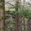
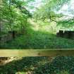
September 2011: Inspection finds the bridge overgrown along its top and bushes and plants have taken root at many points largely enveloping the structure. Some stone have been lost from the parapet. The end of the bridge close to the road has been fenced off. The other end is not visible.
19 March 2014: Inspection finds the building remains in much the same condition as seen previously. Access is blocked at both ends of the bridge, the remaining structure appears stable.
Guides to Development
Conservation Area
Planning Authority Contact
PAC Telephone Number
Availability
Current Availability
Unknown
Appointed Agents
Price
Occupancy
Vacant
Occupancy Type
N/A
Present/Former Uses
Name of Owners
Unverified see FAQ on ascertaining ownership
Type of Ownership
Unknown
Information Services
Additional Contacts/Information Source
Bibliography
Online Resources
Classification
Roads and Paths
Original Entry Date
02-NOV-11
Date of Last Edit
29/08/2014