Ordnance Survey licence number AC0000807262. All rights reserved. © Copyright and database right 2024.
Useful Links
- Canmore:
- MAVISBANK HOUSE, DOVECOT
- Historic Scotland:
- HS Reference No 7386
General Details and Location
Category
AT RISK
Name of Building
Mavisbank Doocot
Other Name(s)
Mavisbank Dovecot
Address
Lasswade
Locality
Postcode
Planning Authority
Divisional Area
Reference No
6611
Listing Category
A
OS Grid Ref
NT 29392 65742
Location Type
Rural
HS Reference No
7386
Description
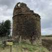
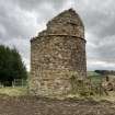
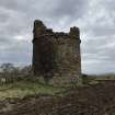
Tall, circular doocot. Upper third partially missing; roofless. Random sandstone rubble with ashlar dressings to doorways. String course at two thirds height; oculus with cill course below to SE face; cill course with no opening to NW face opposite; sunken doorway with relieving arch to SW face with full doorway and relieving arch set above.
No evidence of nesting boxes remains. The building certainly formed an integral part of the designed landscape around Mavisbank. From the house ran three radial avenues and a canal, the central axis terminated by this circular eye-catcher doocot to the NE of the house. The oculus reflects similar features in the pediment and pavilion wings of the main house and the former Jointure House on Linden Place, Loanhead (see separate list entries). A-group with Mavisbank House, Doocot, Gazebo, Walled Gardens, Ice House, Game Larder and East Lodge (Kevock Road, Lasswade). (Historic Environment Scotland)
No evidence of nesting boxes remains. The building certainly formed an integral part of the designed landscape around Mavisbank. From the house ran three radial avenues and a canal, the central axis terminated by this circular eye-catcher doocot to the NE of the house. The oculus reflects similar features in the pediment and pavilion wings of the main house and the former Jointure House on Linden Place, Loanhead (see separate list entries). A-group with Mavisbank House, Doocot, Gazebo, Walled Gardens, Ice House, Game Larder and East Lodge (Kevock Road, Lasswade). (Historic Environment Scotland)
Building Dates
1738
Architects
Category of Risk and Development History
Condition
Ruinous
Category of Risk
Moderate
Exemptions to State of Risk
Field Visits
10/03/2022
Development History
10 March 2022: External inspection finds the structure to be an unconsolidated roofless ruin with unprotected wallheads. There is a large crack in the masonry on the eastern side, running vertically. Entrances to the doocot are unsecured. The structure has been fenced off and signage warning of danger of collapse has been installed. Vegetation around the building is being managed and none appears to have established within the masonry.
Post Survey Update: The doocot sits within the historic landscape surrounding Mavisbank House in the care of Scottish Ministers, managed by Historic Environment Scotland for the benefit of all. It is inspected weekly, checking for changes to condition or vandalism. The vertical crack is long-standing, evident in 1970s photographs, monitoring suggests it is subject to limited movement.
The doocot sits in an area subject to landslips. An area of land to its south has already been lost, warning signs and protective fencing erected to ensure public safety. An engineering solution to prevent further landslips has been installed and is being monitored for effectiveness. Should the pinning of the landslip prove successful this will remove a barrier to the consolidation of the doocot. In parallel to this work, a means to enable safe access for the completion of a full condition assessment is being carefully designed. This will inform a programme of consolidation works to stabilise the doocot.
The Landmark Trust is developing a project to consolidate and restore Mavisbank House. Details can be found on their website https://www.landmarktrust.org.uk/support-us/projects-and-appeals/saving-mavisbank/
Guides to Development
Conservation Area
Mavisbank
Planning Authority Contact
PAC Telephone Number
0131 271 3302
Availability
Current Availability
Not Available
Appointed Agents
Price
Occupancy
Vacant
Occupancy Type
N/A
Present/Former Uses
Name of Owners
Type of Ownership
Information Services
Additional Contacts/Information Source
Bibliography
Online Resources
Classification
Ancillary Buildings
Original Entry Date
11-MAR-22
Date of Last Edit
25/01/2024


