Ordnance Survey licence number AC0000807262. All rights reserved. © Copyright and database right 2024.
Useful Links
- Canmore:
- STENNESS, FISHING STATION
- Historic Scotland:
- HS Reference No 44565
General Details and Location
Category
AT RISK
Name of Building
Stenness Fishing Station
Other Name(s)
Address
Stenness
Locality
Postcode
Planning Authority
Divisional Area
Reference No
5996
Listing Category
C
OS Grid Ref
HU 21444 77120
Location Type
Rural
HS Reference No
44565
Description
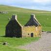
2-storey, 3-bay gabled former trading booth, now roofless. Red sandstone and granite rubble walls. Doorway at ground centring W (principal) elevation; blank bay to left; small window at ground in bay to right and larger window above.
Small window to left in gablehead of N elevation; square rubble- infilled vent centred at ground floor level, window at 1st floor to left. Internal fireplaces centred in gables at upper floor, rubble apex stacks with stone copes.
Small window to left in gablehead of N elevation; square rubble- infilled vent centred at ground floor level, window at 1st floor to left. Internal fireplaces centred in gables at upper floor, rubble apex stacks with stone copes.
Building Dates
19th century
Architects
Category of Risk and Development History
Condition
Ruinous
Category of Risk
Low
Exemptions to State of Risk
Field Visits
24/6/2014, 06/10/2022
Development History
24 June 2014: External inspection finds the former fishing station has had recent consolidation works undertaken to upper levels. Wallheads and lower level walls are in need of repointing.
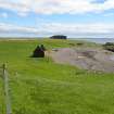
6 October 2022: External inspection finds that the building remains in similar condition to previous site visit. The exposed wall heads continue to decay. Access limited due to livestock in area.
Guides to Development
Conservation Area
Planning Authority Contact
PAC Telephone Number
01595 744762
Availability
Current Availability
Unknown
Appointed Agents
Price
Occupancy
Vacant
Occupancy Type
N/A
Present/Former Uses
Name of Owners
Unverified see FAQ on ascertaining ownership
Type of Ownership
Unknown
Information Services
Additional Contacts/Information Source
Bibliography
Online Resources
Classification
Shops
Original Entry Date
14-APR-15
Date of Last Edit
02/11/2022


